Trans-Arizona Off Road Bicycle Route
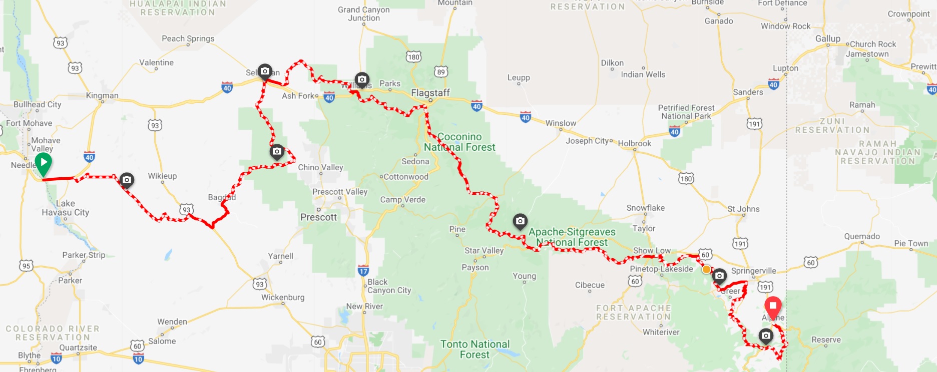
The 630 mile Trans-Arizona Off Road Bicycle Route route is a cross-state adventure ride developed and mapped by the folks from AZ Gravel Rides. The route is made up of non-technical dirt, gravel and forest service roads with less than 20% of the route being pavement. The course is designed to allow high clearance vehicles to follow for support. The western end (suggested direction is west to east) starts on the Colorado River at the California/Arizona border from the historic river settlement of Topock and finishes at Alpine, Arizona. Before arriving at Alpine signs will indicate that you’ve briefly entered New Mexico before re-entering Arizona just in time for the final climb to the finish. There is 66,000 feet of elevation gain! The low elevation is 473 feet at the start at Topock on the Colorado River while the highest elevation is 9579 feet near Big Lake 50 miles from the finish.
The route traverses through a cross-section of Arizona defined by spectacular scenery, a variety of landscapes, historic towns and remote wilderness. You’ll ride along the Colorado Plateau, the Mogollon Rim, San Francisco Peaks, White Mountains and Blue Primitive Area not to mention riding remote sections of the National Old Road Trail and Route 66. There are numerous campgrounds along the way and hotels can be found along the route at Seligman, Williams, Flagstaff, Eagar and Show Low. The finish is in the beautiful Town of Alpine which has numerous places to stay.
This course is suited for both mountain bikes and gravel bikes. The route is very long and requires a lot of planning as it pertains to proper weather gear and resupply. The lower areas have a high concentration of mountain lions and at the higher elevations they are joined by black bears and at least 42 different wolfpacks near the Blue Primitive area. Be prepared! GPX
A gpx file connecting the Trans-Arizona route to the Great Divide Mountain Bike Route can be downloaded at Ride With GPS. The Great Divide Mountain Bike Route (GDMBR) is a 3,083.8 mi (4,962.9 km), off-road bicycle touring route between Jasper, Alberta, Canada and Antelope Wells, New Mexico, USA. Completed in 1997, the GDMBR was developed by Adventure Cycling Association, who continue to maintain highly detailed route maps and a guidebook.
Yavapai Backcountry Loop
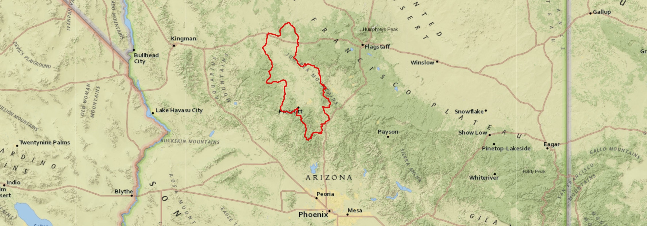
The 330 mile Yavapai Backcountry Loop is made up of non-technical dirt, gravel and forest service roads with only 17% of the route being pavement. The course is designed to allow high clearance vehicles to follow for support. Plan on a two to four day adventure. Most of the course (nearly 300 miles) lies within Yavapai County of central Arizona. The route passes through three mountain ranges; the Bradshaw Mountains, the Santa Maria Mountains and the Black Hills (includes Mingus Mountain). Sections of the course utilize several historical trails and routes including the Overland Road (oldest continously used road in the United States), Beale Wagon Road, National Old Trails Road, Route 66 and the Senator Highway. Sections of the route are also used by several lcycling events including the Chino Grinder, Whiskey Off Road and Bradshaw Grinder. The northern section follows along the 615 mile Ride Across Arizona off road bicycle route. The route can be done on a gravel or mountain bike. The gravel bike would be best outfitted with a 40mm tire or wider. Several short sections of the Senator Highway are hike-a-bike but maybe not on a mountain bike. Keep in mind that this is Arizona. Road conditions can change quickly, I’ve seen the Senator where a passenger car could drive it and a week later a 4WD would have issues. Be prepared and know the route. there are plenty of places to jump off the route if the going gets to tough. Research the course before you start. GPX
Arizona Divide Offroad Trail (AKA “Ride the Arizona Divide”)
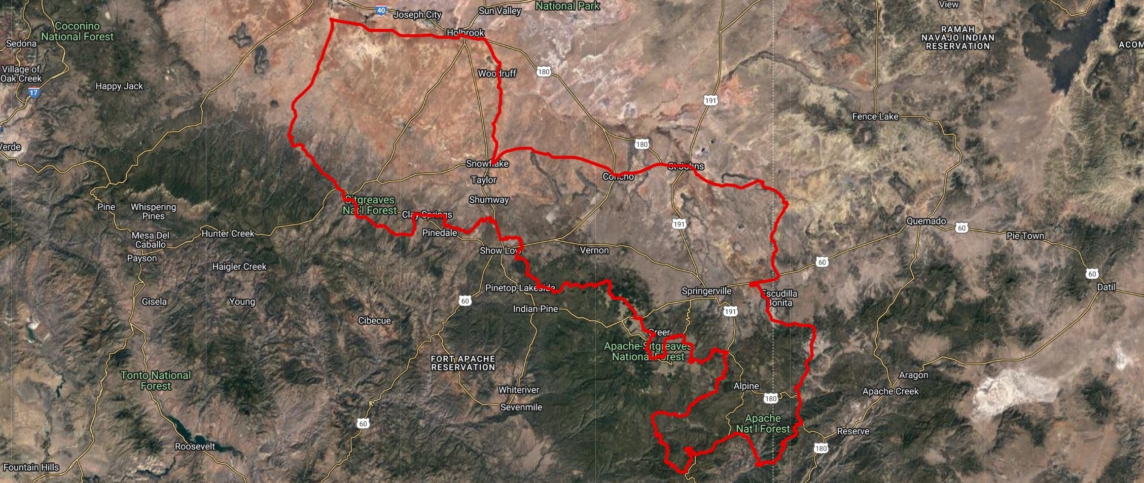
The Arizona Divide Offroad Trail is a 450 mile loop that explores the various sections of the Arizona Divide. The Arizona Divide determines where Arizona’s rivers, streams, and creeks flow. Extending from just west of Flagstaff along I-40 it meanders east across the state following the Mogollon Rim for 200 miles ending near Luna New Mexico.
The rivers and creeks on the north of the divide (Chevelon Creek, Clear Creek, Little Colorado River and the Puerco River) flow into the upper Colorado River while the rivers and creeks (Black River, San Francisco River and the Blue River) south of the divide flow into the Gila River before it joins the lower Colorado near Yuma. The total flow of water from these systems more than offset the 36% allotment we receive from the Colorado River Compact!
The Arizona Divide Offroad Trail visits many historic towns including Heber, Show Low, Greer, Alpine, Blue, St John’s, Snowflake, Woodruff, Holbrook and Winslow. The northern part of the route traverses through the high desert commanding sweeping views in every direction, a stark no man’s land where people and structures are scarce. The southern section of the course is heavily forested, the heart of the White Mountains where you can expect to see wolves, bears and elk.
The course itself is 75% dirt and gravel roads. Completely passable with a 2wd vehicle. If you’re wondering what type of bike setup will work best check out azgravelrides.com/my-bike for what works the best. GPX