Each year portions of the Ride Across Arizona route may be temporarily closed or impassable due to circumstances such as floods, wildfires, mud and road construction. We do our best to keep you informed of these situations, however, they can change on a daily basis. We have provided the following alternate routes to avoid potential closures or impassable conditions along the main route. The Hualapai-Hackberry Alternate is a good option for the summer months as it avoids the extreme heat of the Mojave and Sonoran Desert crossings. The other routes are mainly to avoid “death mud” conditions on sections of the course that do not have a true gravel surface (graded dirt). Keep this in mind when travelling in monsoon season. If you wait just a couple hours after a storm most roads in Arizona will dry out enough to allow travel by bicycle. Monsoon downpours are usually brief and isolated to a relatively small area, wait it out.
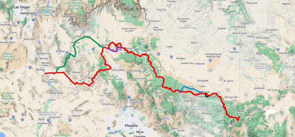
A very challenging alternate to avoid the extreme heat and the monsoons of the summer months (June through September). Although 60 miles shorter than the main route (Signal-Bagdad-Camp Wood) to Seligman do not underestimate this route. It crosses one of the tallest mountain ranges in the state, the rugged Hualapai Mountains. The highest point on the route is at an elevation of 7,056 feet, this happens at just 28 miles from the start of the alternate (for eastbound riders) near the town of Yucca making it the second most difficult hillclimb in Arizona (Fiets Ranking: 10.36). There is a 55/45 split between gravel and pavement. 60 miles of the pavement (good bike lanes) is along the Historic Route 66 between Hackberry and Seligman.
The main RAAZ route in this area (eastbound mile 207 to 252) can become impassable when wet, riders then have the option to follow this route. This alternate travels along a renamed portion of the original Route 66 (Crookton Road) until it merges with I-40. After 4 miles you’ll exit I-40 at the Lewis Avenue exit for Ashfork and ride along 18 miles of lightly used roads before joining the main RAAZ route again at the intersection of CR 124 and FS 6.
The main RAAZ route in this area (eastbound mile 432 to 480) can become impassable when wet, riders then have the option to follow this route. This alternate uses the gravel surfaced Black Canyon Road to access Highway 260 in the Town of Heber. There are several grocery stores and hotels in Heber. The section along Highway 260 to Show Low has a medium sized bike lane.
The main RAAZ route in this area (Maverick OHV Trail, eastbound mile 485 to 495) can become impassable when wet, riders then have the option to follow this route. The entire alternate is composed of paved roads, Porter Mountain and Penrod.
AZ Gravel Rides route descriptions, pictures, maps, gpx etc. should never be copied / shared for commercial use without prior written authorization from AZ Gravel Rides. If you share our routes via social media, GPX or similar we ask that you give credit back to AZ Gravel Rides. All routes are rated using the Arizona Gravel Road Rating System, category 1 (easiest) thru category 5 (hardest). For a detailed description of each category and examples check out: azgravelrides.com/arizona-gravel-road-rating-system