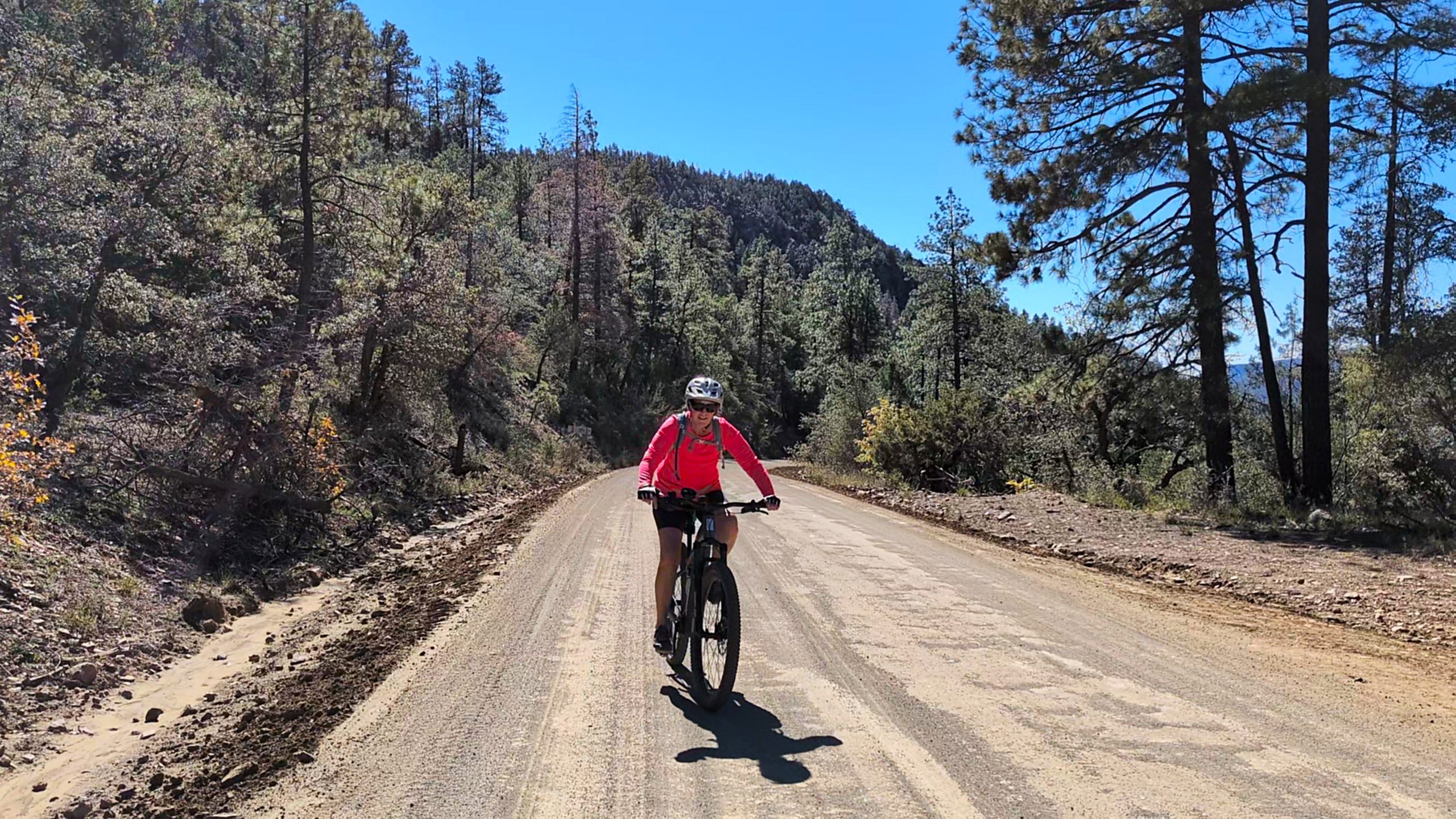
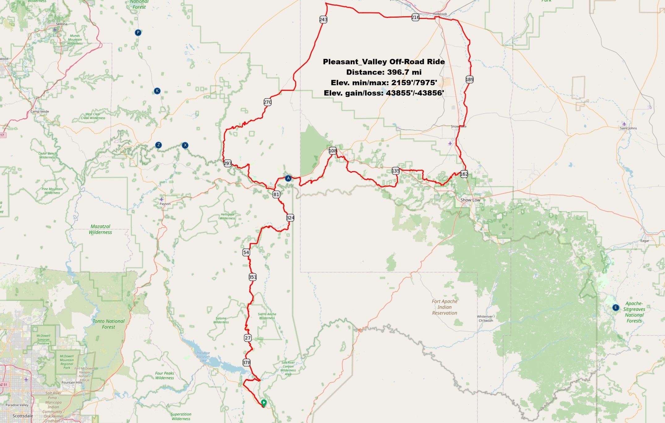
This isn’t your average weekend spin. With over 44,000 feet of elevation gain, climbing from a low of 2,000 feet all the way up to 8,000, this 400 mile route is a serious challenge. But the reward is an unforgettable experience, riding through the very landscapes that witnessed one of Arizona’s most brutal historical conflicts: the Pleasant Valley War.
From 1882 to 1892, this region was torn apart by a decade-long feud between two ranching families, the Grahams and the Tewksburys. What started as a dispute over cattle rustling and grazing lands exploded into Arizona’s bloodiest range war. This wasn’t just a disagreement; it was a saga of ambushes, lynchings, and murders that became the stuff of legend. The Pleasant Valley War had the highest number of fatalities of such range conflicts in United States history, with an estimated total of 35 to 50 deaths, and the near annihilation of the males of the two feuding families.
As you pedal through this rugged terrain, you’ll be tracing the footsteps of history. The route passes through or near key towns embroiled in the conflict. You’ll traverse Pleasant Valley itself, now known as Young, which was the epicenter of the fighting. You’ll ride near places like Holbrook and Globe, where cowboys and sheepmen clashed in saloons. The story even extends to Tempe, where the final, fatal act of the feud played out with the ambush of Tom Graham.
The conflict’s origins trace back to communities like Snowflake and Woodruff. It all began when a major rancher, James Stinson, accused both families of stealing his cattle after he sold his ranch to Mormon settlers who founded Snowflake. Tensions escalated when a warrant from Woodruff was issued for Jim Tewksbury, which the family saw as a setup by their rivals. This fueled the paranoia and bitterness that led both sides to arm themselves, igniting the deadliest phase of the war.
Riding this route, you can almost feel the history in the air. The vast, empty spaces and rugged canyons haven’t changed much since the days of the Graham-Tewksbury feud. It’s a powerful way to connect with the past while pushing your own physical limits.
So, when is the best time to tackle this beast? The desert heat can be brutal, so fall and spring are ideal. For more info on the route email ridingazgravel@gmail.com.
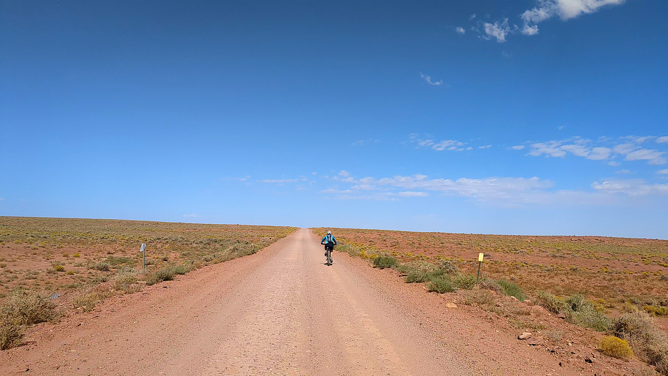
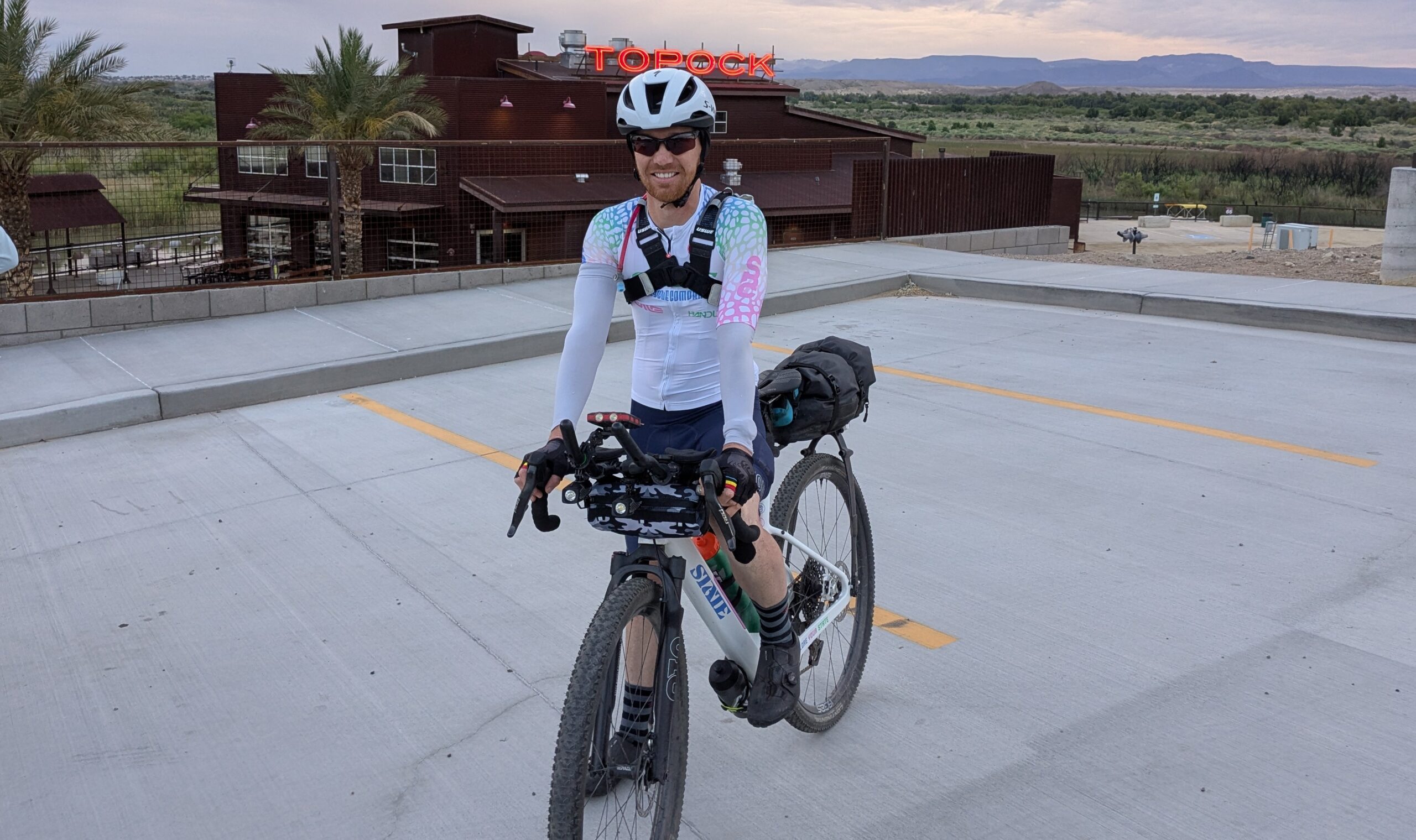
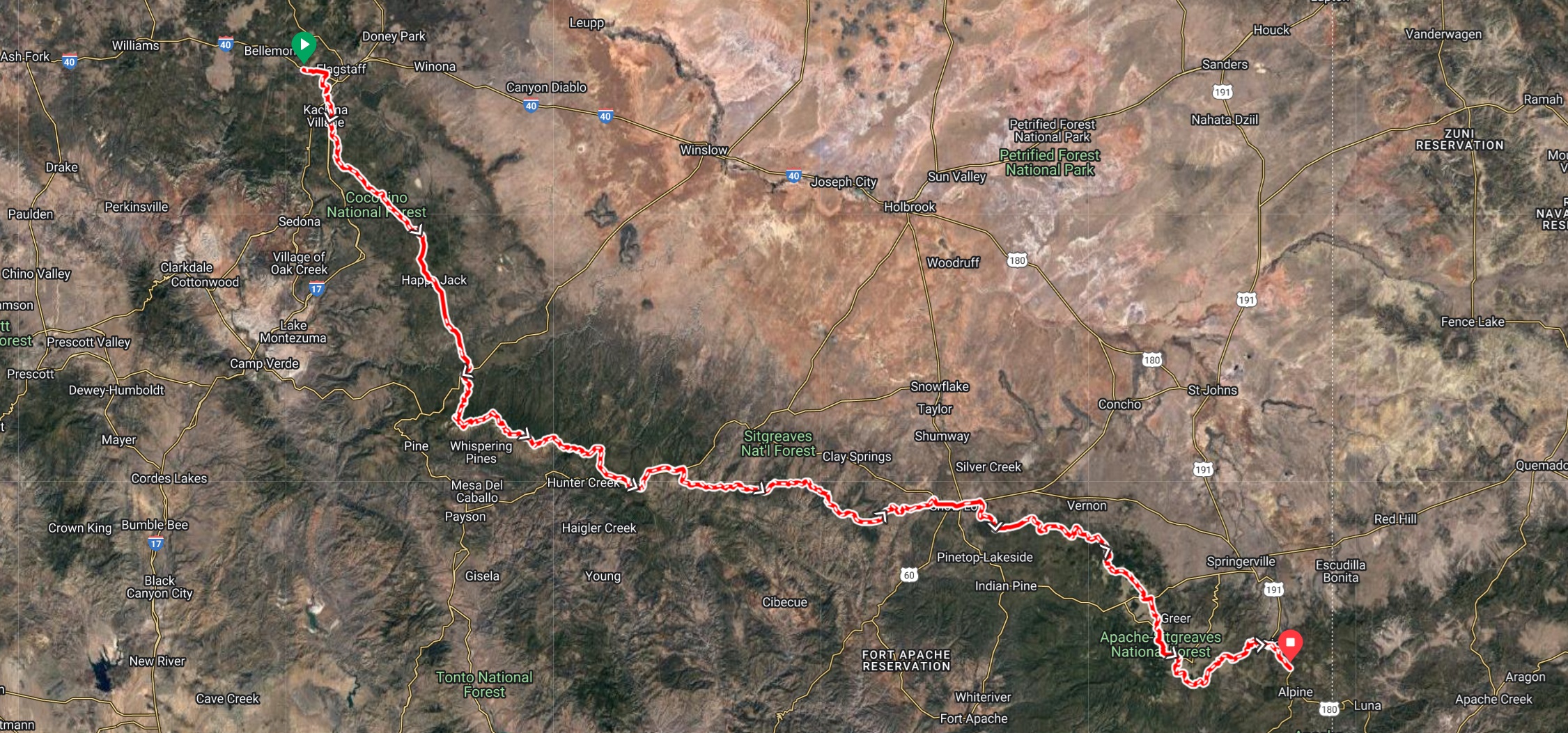
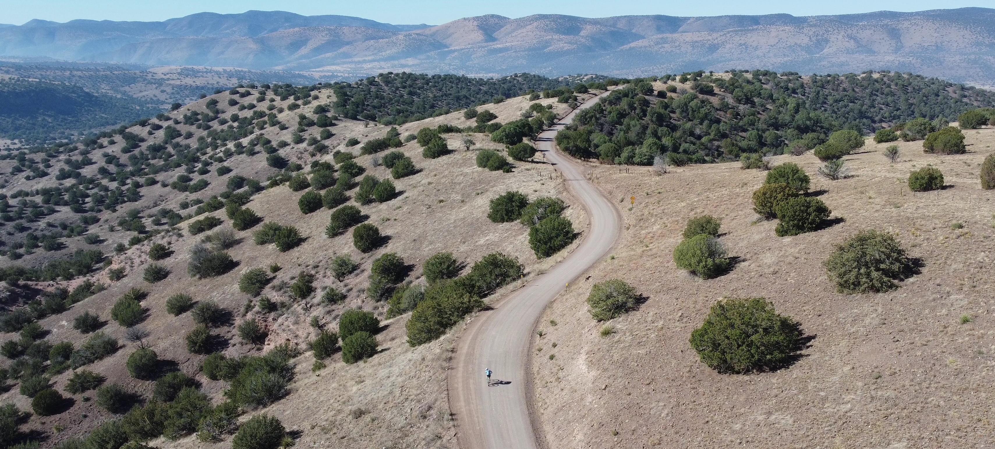
The 616 mile Ride Across Arizona is a cross-state gravel road adventure ride that we first documented in 2020. The route is made up of non-technical dirt, gravel and forest service roads with less than 20% of the route being pavement. The western end starts on the Colorado River at the California/Arizona border from the historic river settlement of Topock and finishes at the New Mexico border near the remote outpost of Blue Arizona. By the time you arrive at the finish you’ll have crossed deserts, windswept mesas and several mountain ranges. Unless you plan otherwise no one will be there to greet you at the finish, it is remote!
The Ride Across Arizona traverses through a cross-section of Arizona defined by spectacular scenery, a variety of landscapes, historic towns and remote wilderness. You’ll ride along the Colorado Plateau, the Mogollon Rim, San Francisco Peaks, White Mountains and Blue Primitive Area not to mention riding remote sections of the National Old Road Trail and Route 66. There are numerous campgrounds along the way and hotels can be found along the route at Seligman, Williams, Flagstaff, Forest Lakes and Show Low. The finish is near the beautiful Town of Alpine which has numerous places to stay.
Since 2021 my wife and I have made this a yearly ritual where we start at sunrise (6:00am) from Topock on the Cali border on the first Monday in May and ride non-stop until we reach the New Mexico border near Blue Arizona. This seems to be the best time of the year to ride. The temps are not too bad in the deserts and generally the forest service roads and campgrounds are open the 1st of May for the start of the summer season.
From the start at Topock Route 66 Resort on the Cali/AZ border along the Colorado River the first 13.5 miles follows I-40. This is a wide bike lane. From year to year it varies on how much debris exists. The last two years have been better. I personally ride as far to the right as possible.
After exiting at Francona Road you’ll hit mostly hardpack dirt. A lot of embedded rock so if you don’t have suspension you’ll definitely know you are not on pavement anymore. From Francona you’ll jump on an original and historical section of the National Old Trails Road. This was the original coast to coast highway opened in 1921. It follows a Native American trade route in use since 1100 AD that traverses from the Hopi village of Oraibi to the Pacific Ocean just north of modern day LA. It is the oldest continuously used road in the United States. Mostly rideable but there are a couple of short sections of sand that may require a dismount.
At mile 17.5 you’ll turn left on to a smooth super fast atv trail that connects with the paved Unna Road adjacent to I-40. Follow Unna for four miles before heading east on Santa Fe. After 6 miles you head south on Butch Cassidy Road. This is new for 2025 added to avoid a recently paved section of the Alamo Road. After riding five miles you’ll make a left on Fireside and then a short jaunt on Geronimo before you come up on Alamo Road. Now you are out in the boonies! Follow Alamo for 25 miles before turning left onto Signal Road. This is mile 65 of RAAZ. I like to remind myself that at mile 60 I have completed 1/10th of RAAZ! Signal Road is a fairly easy stretch if it’s been graded recently. Like Alamo it has pockets of sand that can interrupt your momentum but nothing too severe. Hopefully Mary will have a water station set up again for us at her ranch at mile 73!
After crossing the Big Sandy River the route changes to 17 Mile Road, one of the toughest sections of the entire RAAZ route. In the next seven miles you’ll do several climbs that exceed 30% but the reward will be at the top with sweeping views of the Burro Creek Wilderness and the Bagdad Mine as you begin an almost constant descent until you reach the Wikieup Highway at mile 88.
From that point the route remains paved until Bagdad. You do have an option to avoid some of the pavement although no one used it this past year. At mile 93 you can follow an 8 mile off road trail that eliminates nine miles of pavement. The first four miles of that route can be rather challenging but the remaining 4 miles consist of graded dirt that is usually in excellent condition. I can ride the entire first four miles but chose to dismount twice on downhills as I tend to be more cautious when riding alone.
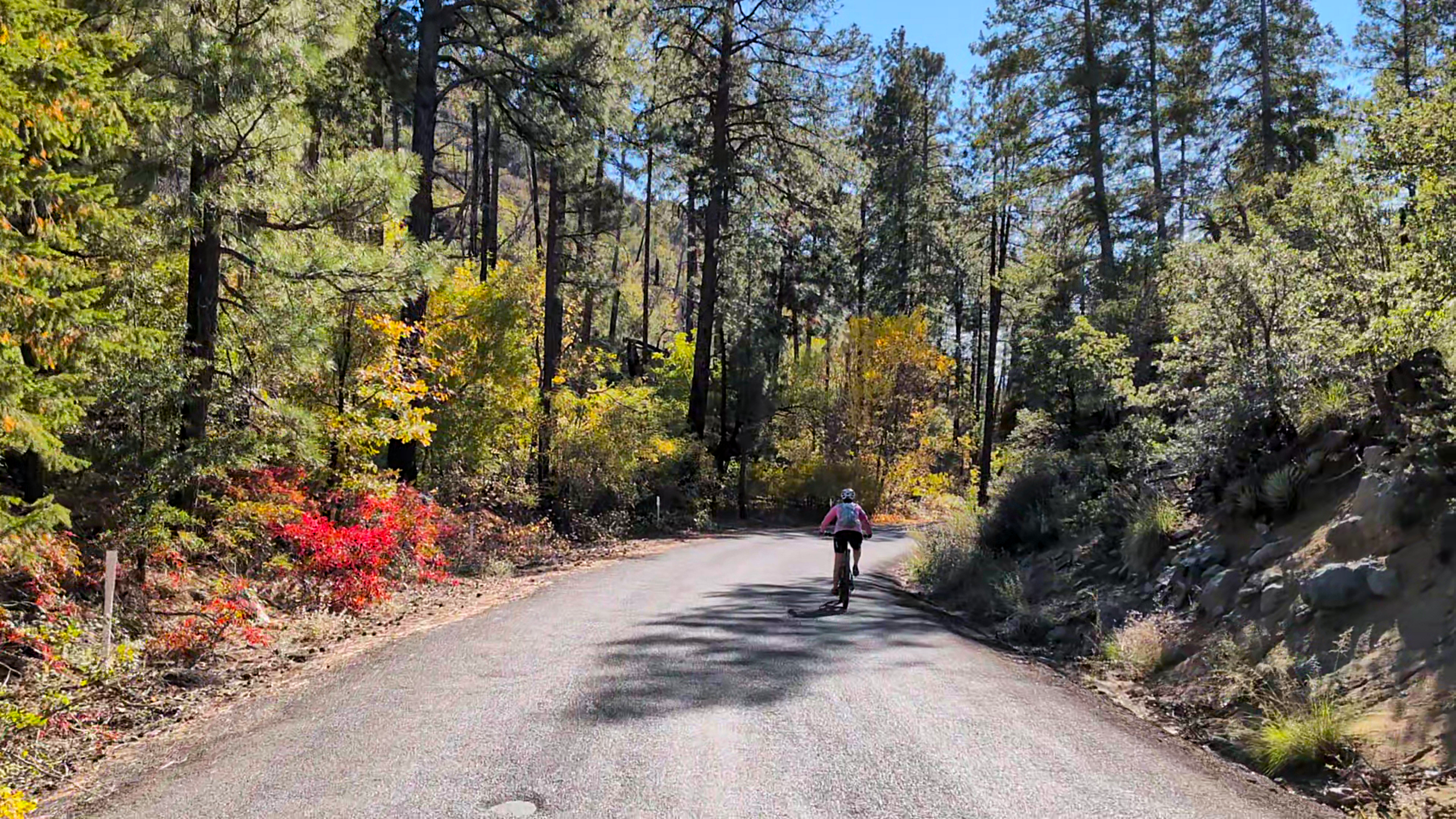
Bagdad is a company owned town and there is no public lodging available. They do have a Basha’s grocery store and a Circle K where you can re-supply as needed. As you are leaving town, about a mile up the road, there is the Copper Country Bar & Grill. Great food and excellent service. This is your last chance to get a meal until you reach the Subway at Seligman! After a 20 mile climb out of Bagdad you’ll enter Behm Mesa before passing through the historic Yolo Ranch at mile 24. The ranch encompasses over 110,000 acres of high-country land in Arizona. Established in 1885, they run over 1,500 head of cattle on some of the most beautiful and varied country in the state. From there you will continue through the Ponderosa pine forest to Camp Wood before starting a 15 mile downhill to the northbound Williamson Valley Road. This section crosses a huge basin known as the Big Chino Basin. Basically a shorter version of the Tour Divide’s Great Basin through Wyoming. Pray that you have a wind out of the southwest! The closer you get to Seligman the more washboard you’ll encounter, you’ll be relieved when you finally hit the pavement.
Seligman is a cool little town located on the old Route 66. There are numerous restaurants, hotels and a KOA. We usually stay at the KOA, it is literally right on the route. If you love trains this will be heaven for you. Transcon is one of the most heavily trafficked rail corridors in the United States with an average of almost 90 trains daily (over 100 trains on peak days) passing through this section with each train typically 6,000 to 8,000 feet long.
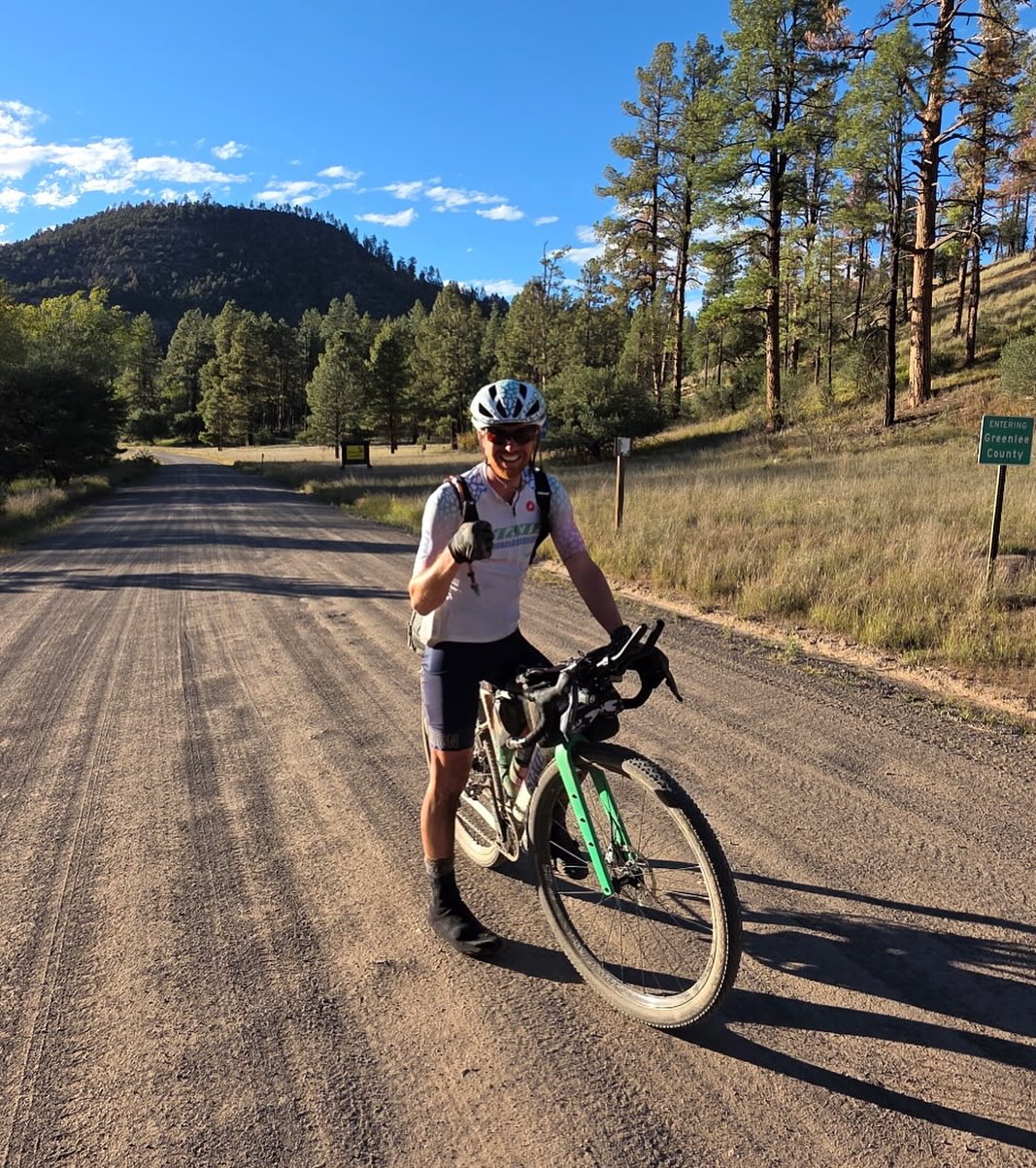
The 104 mile third section of the Ride Across Arizona travels from Seligman to Flagstaff. For me it’s a toss up with Alpine as my favorite section of the entire route. Even though it’s near very popular areas of the state for recreation (Grand Canyon, Williams area and Flag) it remains off the beaten path. Hardly any motorized vehicle traffic, it just feels very remote and their is abundant wildlife.
This route covers arguably the most historically significant area in the state of Arizona known as the 35th Parallel Route. This is the original Hopi trade route originating out of the village of Orabai, the oldest continually inhabited settlement in the United States (founded 1000AD). The ancient Hopi trade route passed through northern Arizona following a series of waterholes (including Russel Tank, mile 21) on its way to the Pacific Coast in what today is the Los Angeles area. This route is also associated with historical figures like Captain Lorenzo Sitgreaves and Lieutenant Amiel W. Whipple, who mapped the area in the 1850s for a potential railroad to the Pacific, and Edward Beale, who explored it with camels for a wagon road. The route crosses the state roughly between Winslow and Kingman.
You will eventually eventually connect once again with the National Old Trails Road which takes you into Williams. This section of the National Old Trails route also travels along the Transcon rail line. It is so awesome to be in the middle of nowhere and see and feel a big five engine 2 mile long train go rumbling by at high speeds (the rail is rated for freight speeds up to 90 mph!). Once in Williams you’ll find a Safeway store along with numerous hotels, restaurants and breweries. There are several USFS campgrounds in the area including Dogtown Lake Campground which is located on the route.
From Willams it’s onto Flagstaff, a mountain city located at 7,000 feet elevation within the world’s largest contiguous ponderosa pine forest, known for its four-season climate, outdoor recreation, and astronomy heritage. It is a central hub for exploring numerous natural and historical attractions in Northern Arizona, including the Grand Canyon. Flag has numerous hotels, bike shops, grocery stores etc. Plus!.. a Circle K right on the course!
Seligman, Williams and Flagstaff are all original Route 66 towns. Route 66 will celebrate it’s 100th Anniversary this coming year. Celebrations are planned so it’s a great time to visit!
Section 4 of the Ride Across Arizona stretches from Flagstaff to the community of Forest Lakes where Highway 260 intersects with the Mogollon Rim. The Rim is a 200 mile long escarpment defining the southwestern edge of the Colorado Plateau. You’ll have crossed two deserts and three mountain ranges before the start of this section across the Colorado Plateau. You’ll feel every bit of it too! Weather can be very unpredictable along this section. During the 2022 version of the event the leaders that year made it through this section with excellent weather. From the mid pack and back not so much. Wind gusts were recorded at 60 mph. At times it was nearly impossible to ride your bike, especially directly along the Rim. I pushed my bike into a headwind for a couple miles on the climb out of Clear Creek and was constantly needing to unclip in order to keep from getting knocked over from treacherous side winds along the Rim.
The route starts in south Flagstaff where there are a number of places to re-supply. Make sure you do. You won’t see another store until Forest Lakes. After leaving Flag the mostly dirt road meanders through the ponderosa pine forest before hitting the paved Lake Mary Road approximately five miles south of the Mormon Lake community. You’ll travel south on Lake Mary Road for 15 miles before jumping off on FS 211. From this point on you’ll be on dirt and gravel roads until the last three miles before crossing Highway 260. There are 40+ numbered primitive camp spots spread out along the 2.5 mile road between Hwy 260 and the Young Highway. Perfect place to spend the night.
The 134 mile (with nearly 14K of elevation gain) section 5 of the Ride Across Arizona 2025 stretches from the community of Forest Lakes to Big Lake. Starting from Forest Lakes you’ll once again jump on the Rim Road (FS 300) for a mostly downhill 60 mile cruise along arguably the roughest section of Ride Across Arizona. Geologists refer to this area as “Rim gravel”, referring to ancient gravel deposits often found on high plateaus in northeastern Arizona which are remnants from past erosion due to the uplift of the Colorado Plateau. From there you’ll jump on the pavement as you make your way through Show Low but not before you pass the Travis Walton abduction site. Forestry worker Travis Walton was allegedly abducted by aliens near RAAZ mile 442.5 on November 5, 1975 in the Apache–Sitgreaves National Forest near Heber, Arizona. Great camp spot too! Once in Show Low there are numerous places to dine and stay (campgrounds, hotels) plus a bike shop. After leaving Show Low you’ll hook up with the Maverick Off-road Trail and eventually on to FS-267/N3566. This is where the fun starts as you’ll begin the climb up to Green’s Peak and at an elevation of 9,572.8 feet the highest point of the entire ride. The views are astonishing and you’ll most likely have the chance to cool off sitting on a drift of snow that has not yet melted! After Greens it’s a ripping downhill to the next slight climb and before you know it you’ll be at Big Lake. There are five campgrounds, showers and a store at the lake. As we get closer to the May start I’ll contact them to get the store hours and the status of the campgrounds.
The sixth and final section of the 615 mile Ride Across Arizona goes from Big Lake to Blue. It is 51 miles to the finish at the New Mexico border at the remote outpost of Blue Arizona. At mile 595 you will pass over the Coronado Highway, now known as US 191, which has a history stretching from the 16th-century Spanish expedition led by Francisco Vásquez de Coronado to the modern-day scenic drive it is today. Construction on the modern, 124-mile road through the Apache-Sitgreaves National Forests in eastern Arizona began in 1916 and was completed in 1926, replacing a longer wagon route. Initially designated as part of U.S. Route 666, it was renumbered to U.S. Route 191 in 1992 due to negative publicity associated with the “Devil’s Highway” nickname.
After crossing the highway you will enter the Blue Range Primitive Area: it is the last remaining federally designated “primitive area” in the entire U.S. National Forest System. All other areas with this original 1930s status were eventually reclassified as Wilderness Areas under the 1964 Wilderness Act. Because of its remote location, lack of development, and difficult access, the area receives very few visitors, offering exceptional solitude. The area is a vital habitat and part of the Mexican Gray Wolf Recovery Zone, home to black bears, mountain lions, elk, and a wide array of bird species.
For over 100 years the fight to prevent the Blue from being designated a wilderness area involves local ranchers who historically opposed the designation and continue to do so, citing concerns that wilderness status would impact their livelihoods and mining potential. Local ranchers, some of whose families have ranched in this area from the 1800’s, have consistently opposed wilderness designation, arguing it interferes with their use of the land, although the government has worked to acquire some of the private land in the area, which has reduced the number of permitted ranchers.
Remember there are no stores in Blue. There is a well stocked country store at Big Lake. That is the only place along this route to resupply. There are two small campgrounds near the community of Blue, the Blue Crossing Campground and the Upper Blue Campground if you don’t feel like riding into the town of Alpine. Both campgrounds feature Adirondack-style shelters plus a vaulted toilet. The Blue River has water but you will need a filtration system. That five mile climb to Alpine after re-entering AZ is a brute!
We caught up with Tyler just days after setting the new FKT for the 616 mile Ride Across Arizona, Arizona’s hardest gravel road ride, to discuss what it takes to succeed at this monumental challenge.
What attracted you to take on Ride Across Arizona (RAAZ)?
I’ve always been drawn to the idea of adventure. Ever since I was a kid, a bicycle has been a source of freedom and exploration. There’s something magical about traveling across a landscape under your own power that you can’t replicate in a vehicle. It started with a 2-mile ride to the local Country Store to buy candy and has been a part of my life ever since. So not only did RAAZ check the boxes on “Adventure” and “Exploration”, but it also let me explore what I’m capable of. In a world where we are chronically comfortable, challenging myself physically and mentally makes me feel alive. It’s exciting attempting something that you’re not quite sure if you pull off. In fact, I DNF’d RAAZ twice before. I guess 3rd time’s the charm!
How were you feeling heading into RAAZ after your first two attempts were thwarted by weather?
I was nervous and a little embarrassed to be honest. After 2 failed attempts, I was quieter about my intentions to try a 3rd time. My first attempt at the Grand Depart was thwarted by rain and peanut butter mud that was impassable. I tried again a month later, but the heat in the Mojave desert affected me in a way that it never had before. I got heat exhaustion, and my friend Tom had to come rescue me (thanks Tom!). My wife, Annie, rescued me the first time in the middle of the night. Have I mentioned how amazing she is yet?! So, the 3rd attempt, I was pretty nervous and decided to wait until it got cold. I knew the cold wouldn’t kill me as long as I kept moving.
You clearly excel off-road but have enjoyed success in other disciplines. Which do you think you are best at?
I’m pretty “ok” at everything but not the best at anything. I’ve been doing road racing for about 15 years and spent about 15 years as a runner before that. So, I’ve always been an endurance athlete and just started gravel racing in the last 2 years. I enjoy it because you don’t need incredible technical skills like mountain biking and it’s harder than road races where you can just “sit in” and sprint at the end. If I had to pick, I’d probably say I’m best at gravel racing because the races are long and difficult enough.
Bike setup is a big talking point for any bikepacking event. What was your setup for RAAZ and would you make any changes in hindsight?
I rode the State Bicycle Carbon All Road gravel bike set up the SRAM Red wireless components. I had carbon ENVE wheels with 2.0” Continental Race King mountain bike tires, carbon ENVE handlebar/stem with ENVE clip-on aerobars. I used the RedShift Sports suspension seatpost. The State Carbon All Road held up incredibly well, and I didn’t have any mechanical issues whatsoever with the bike.
To carry my gear, I used the Tailfin Aeropack, which was great. It’s super stable and holds a ton of gear. How you keep things organized gets worse as you keep riding, so having a little extra room is really valuable. I also had 2 toptube bags, a small triangle bag below the top tube, handlebar bag, and 2 feed bags attached to the handlebars. Lots of small bags worked well to keep things organized, and I was able to carry 4 water bottles (3 on the bike and 1 in a feedbag). I also had a USWE hydration pack with 2L of water in it.
The only change I would make is to run a suspension fork like the State Bicycle Company gravel suspension fork. My hands, wrists and shoulders are incredibly sore, and I should’ve used one for RAAZ. The route is definitely not “champagne gravel”!
Any major surprises concerning the route?
I knew it was a rough course, but the sheer number of miles of chunky/rocky gravel was far more than I expected. I expected Rim Road to be rough, but it just seemed to never end. I tipped over 3 or 4 times riding that section in the dark.
What did your training plan consist of? Ride lots or structured?
With 2 young kids at home and a (amazing) wife who also likes to run/ride, it’s hard to fit lots of rides in per week. So, I’ve been doing 3 group rides each week and usually start super early to get in a few hours before each ride. Most mornings I’d start around 3am and then begin the group ride at 5:30. I also did a few overnight rides where I’d start at 8pm and ride through the night into the morning. I wanted to see how I would respond to no sleep in preparation for RAAZ. So far, I’m up to 7,770 miles for the year riding just 3 days per week.
What role did rest and recovery play in your strategy? It looked like you barely stopped, was that intentional?
I knew I would be able to ride through the 1st night since I had practiced it. I brought a bivy and sleeping bag liner in case I needed to sleep the second night. But it was so cold that I knew I’d probably just lay there freezing and not get any sleep. So, I went the whole ride without any sleep. I felt incredibly fatigued and had a hard time concentrating, but I never felt like I was going to fall asleep on the bike. I think my Strava file said 6 hours of stopped time (52 hours of moving time and 58 hours of total time. These are rough estimates of course). I stopped at each town to warm up and get “real food”. I kept craving a cheeseburger or pizza. I was pretty tired of gels and drink mix.
Did you expect to set a new race record? How did that motivate you to keep moving when times got tough?
I was certainly hoping to. I knew Dana Ernst was incredibly strong, and everything would have to go right for me to beat his time. I had some pretty dark moments in the morning of day 3. The headwind was so strong that I was going 3mph on flat roads. I started to worry it’d take me another day if the wind didn’t let up. Thankfully, the course goes back into the forest where the wind wasn’t as bad.
Another unfortunate circumstance was that one of my battery banks stopped charging and I also lost one of my lights on a downhill in the dark on the first night. So, I was down to 2 lights and half a battery bank to charge all my electronics. I worried I’d run out of lights before the end of the ride, so I stopped using my phone for music or audiobooks. This left me with just my own thoughts to listen to, which I can assure you, is less entertaining than you might imagine!
How does establishing the new FKT for RAAZ compare to past victories?
I’ve won some road races and gravel races in the past, but this feels much more satisfying. I think because I failed so miserably the first two times, that finally completing it this time around made it feel so much more rewarding. It was also much harder and more painful than other events. With nothing to listen to, I started making a list of all the things that hurt. I realized the list of “things that don’t hurt” was shorter: my elbows, my chin, my right pinky.
Which is more difficult, riding ITT or Grand Depart?
ITT was more difficult mentally. The Grand Depart was more fun having a group there, and I felt more encouragement and comradarie. Unfortunately, doing the Grand Depart is on a set day, so the weather may not be ideal like it was this year. I would recommend doing the Grand Depart, but be willing to postpone if the weather doesn’t look promising. The route starts at 500 ft above sea level and goes to 9,000+. So, there’s a pretty small window of opportunity where weather will be “ok” for the entire route.
Any advice for someone taking on this route?
The State Bicycle Carbon All Road with mountain bike tires is the perfect rig. I would 100% do suspension fork and suspension seatpost though! Other than that, I’d say really think about what your goals are. I wanted to do it as fast as possible. But I think taking your time and camping would be incredibly fun. The RAAZ route was incredibly difficult, yet beautiful, varied in terrain, challenging, and rewarding. I’d encourage anyone who wants to try part of the route to ride the last 100 miles or so near the NM border. Despite being incredibly tired and wanting to be done, I couldn’t help but still me amazing by the beauty around me.
Overall, I would encourage anyone to get out of their comfort zone. Go do something challenging. You might fail (I know from experience!), but again…maybe you won’t! You might just surprise yourself.
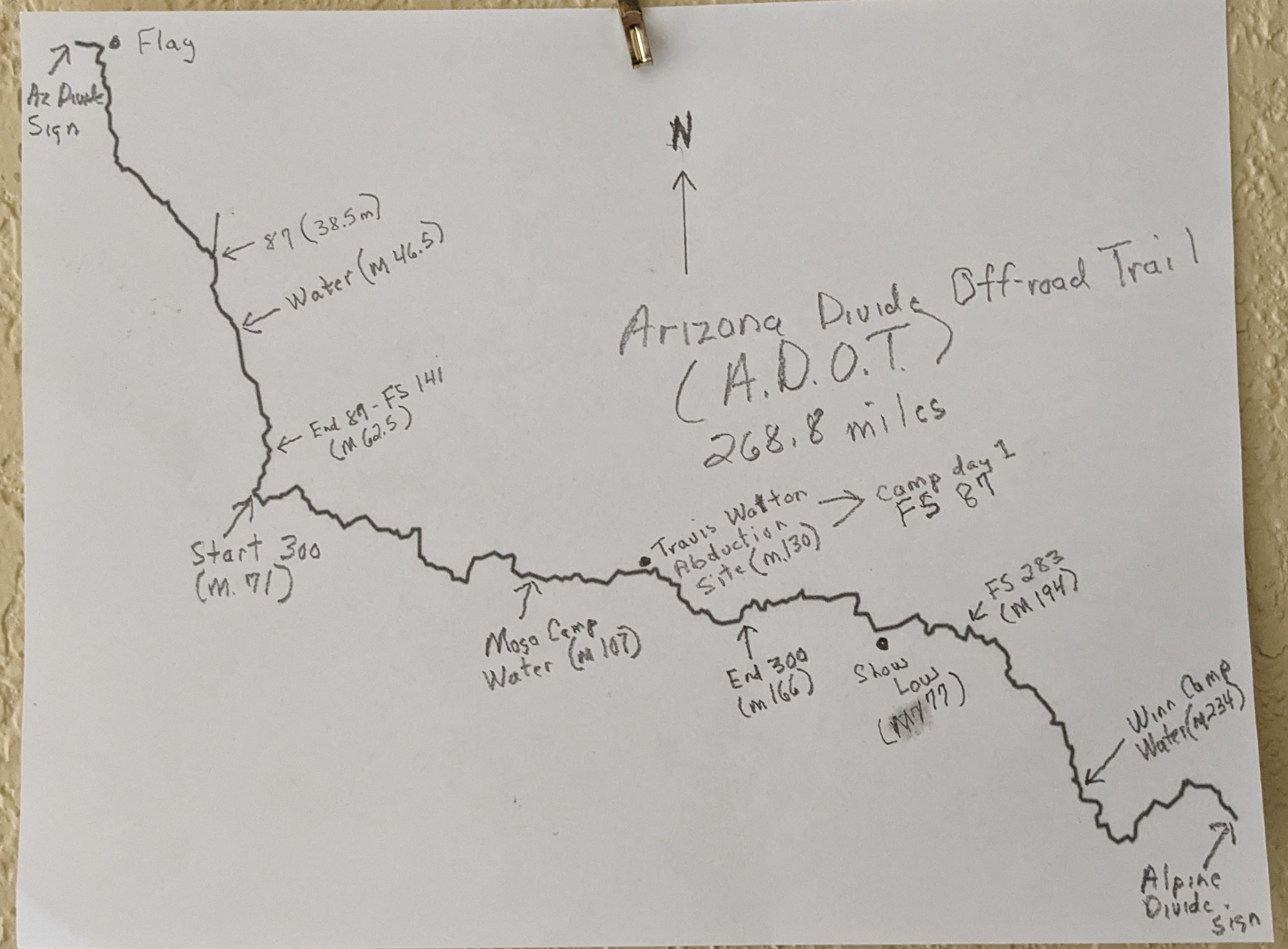
The Challenge: To ride the entire Arizona Divide Off-Road Trail completely self reliant. No phone, gps, tracking device, visitation, outside support, hotels or markets (BLM, AZ State Parks and USFS Campgrounds are okay)
Reason: To encourage and inspire others (especially the elderly) to get out and enjoy the outdoors and realize the many benefits of exercise, especially in combatting dementia, heart disease and age related cognitive decline. Also to better understand exactly which modern conveniencesprovide the most comfort and support on a solo bikepacking trip.
2024 marks the 15th year I’ve been retired and also my 70th birthday. Every year since I’ve retired I have scheduled something
epic as motivation to stay fit and to force me to think outside the box. For my next adventure I’m planning on a solo unsupported bikepacking trip riding the entire 270 mile Arizona Divide Off-road Trail. This will be my first attempt at bikepacking. To challenge myself further I plan on doing it with minimal resources including no electronics (no phone, gps or tracking device) along with the commonly accepted rules of non supported bikepacking (no visitation, no outside support, no film crews, etc) and doing it at minimal cost. Plus I won’t be purchasing anything from stores or paying for lodging while trying to be as self reliant as possible (no need for credit cards or cash). The only electronic device will be my Drift Ghost Action Camera (has no internet access or communication options) to document the ride, with the two batteries it has 15 hours of recording time. Planning on a May/June timeframe and hoping to finish in less than three days. Due to cataracts I can no longer see at night so I will only ride sunup to sundown. This will enable me to keep my normal sleep schedule of seven hours each night.
The Route:
The Arizona Divide Off-Road Trail (developed by AZ Gravel Rides) stretches 270 miles starting from the Soggy Bottom Ranch Road,
directly adjacent to the ADOT Arizona Divide sign at mile marker 190 on I-40 (west of Flagstaff), to the ADOT Alpine Divide sign at mile 422 on U.S. Highway 191. The route is over 77% dirt and has nearly 30K of elevation gain. GPX for the route can be found at https://azgravelrides.com/:arizona-divide-offroad-trail/
Since I will not have access to any type of electronic tracking device ( gps device, odometer, cell phone etc.) I will need to rely on a hardcopy map. I have drawn one up and included some mileage and reference points to help provide me with an indication of my progress. There are two sections that could be tricky to follow, the first is the section from the start to mile 12. This involves numerous intersections, I don’t want to waste any time or energy overshooting one of the many turns. I have already familiarized myself with that section so no concerns there. After that section it is relatively straightforward, especially the 95 mile section along FS 300, the Rim Road. The other troublesome section is mile 194 on the road to Vernon. I’ve ridden that section a number of times but because I was staring at the gps navigation I never paid much attention. I do know that FS 182 is signed and about a third of a mile past where the road turns from pavement to a brilliant white dirt and then a half mile past that is the turn onto FS 283. This is the start of by far the toughest section of the entire route. A huge climb to mile 220 and Greens Peak. From there to Big Lake and the finish is relatively straight forward.
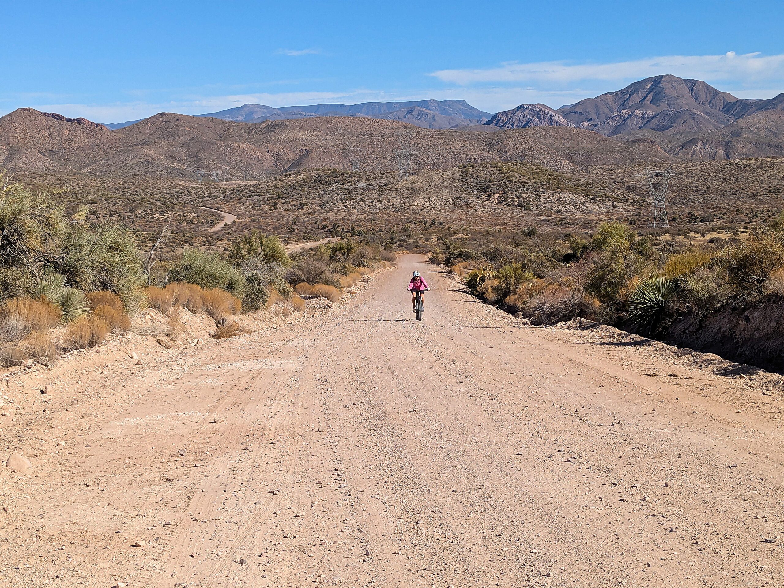
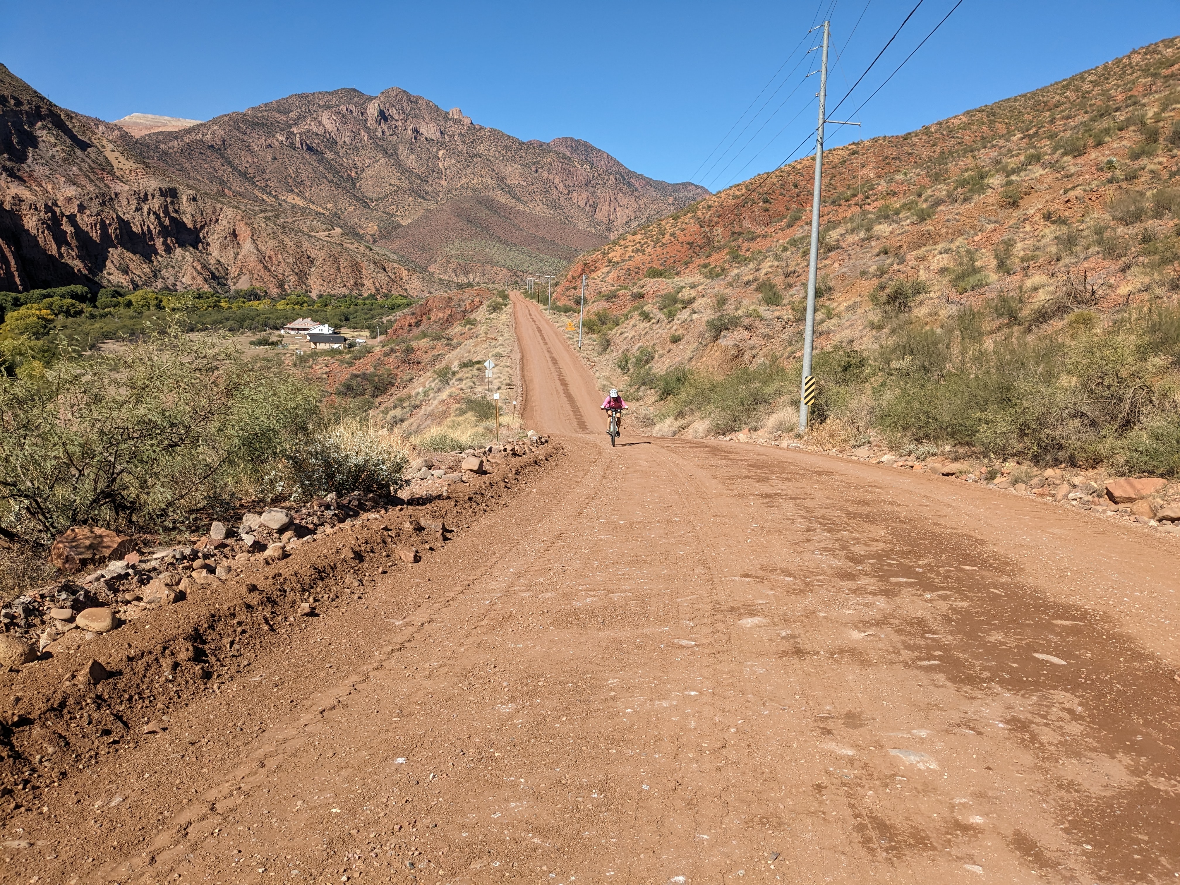
For those that follow this site or our social media accounts you know our passion for discovering and exploring remote areas to ride in. Our latest adventure took us to the Town of Clifton Arizona located in the southeastern section of the state. We were looking for something remote and we definitely found it in Greenlee County, the least populated county in AZ. After doing some preliminary research of the area we decided on three areas to explore; Upper Eagle Creek, the Lower Blue and the San Francisco River.
From Clifton we drove 28 miles north on Hwy 191 to the intersection with Upper Eagle Creek Road. There are several parking areas near the start of the ride. The first 10 miles you’ll drop from 6300 feet to 4800 feet in elevation. The remaining 12 miles of the ride is a gradual uphill to the end of the road at Honeymoon campground. During the entire length of the ride I would guess there are about 25 residences. Public utilities do not exist, each ranch is self sustained generating their own electricity and all water comes from wells. There are three water crossings of Eagle Creek, a foot deep at the most. At mile 22.5 we came to Honeymoon Campground and the end of the road for motorized vehicles. East Eagle Trail #33 (open to mountain biking) continues on for 12.6 miles to Hwy 191. If you decide to give this trail a try the first 6 miles is an old jeep road. There is a cabin, Sawmill Cabin, at 7.5 miles. This cabin is maintained by the grazing permit holder but is open to the public. The entire length of this road is very well maintained with little motorized traffic.
As remote as it is, people have been living in this area since prehistoric times. It’s totally understandable, it is gorgeous! Geronimo even tried to bargain with General George Crook for an end to hostilities in exchange for this valley. Near mile 11 you’ll start to pass through the area of the double Circle Ranch, at one time the second largest employer in Greenlee county. Between 1900 and 1936 they were running over 30,000 cattle on 37,000 acres. 20 full time cowboys and a herd of over 350 horses kept the ranch running. The ranch even maintained a commissary where many folks living in the Eagle Creek valley would get their supplies. The ranch met its demise when the San Carlos Apache tribe failed to renew grazing leases on their lands that lay immediately west of the ranch. Ownership of the old ranch changed so fast over the next few decades that even locals lost track of it. In 1950, the then owners attempted a dude ranch, constructing the current lodge and cowboy bunkhouse, and somewhere along the way a 2,400’ airstrip was bladed in just north of these structures. Not sure of the status of the ranch today. It looks to still be maintained and there is a fairly new sign for the old schoolhouse.
Located just a couple miles north of Upper Eagle Creek Road this road provides access to the lower Blue River Area. We found the entire 13.6 mile stretch of this road in perfect condition. Starting at 6000 feet it’s mostly downhill until you bottom out at the Blue River crossing at 4000 feet. The road continues on to a ranch but we turned around at this point. There are two campgrounds near the start of this ride, Upper Juan Miller and Lower Juan Miller, that are open year round. Near mile 12 is the road back to the abandoned XXX Ranch. Built by one of the first settlers of the area, Fred Fritz, the ranch is now maintained by the Forest Service and is open to the public. In 1899 Fred Fritz was attacked by a grizzly bear in nearby Maple Canyon and barely survived. You can read the story here. His son Fred Fritz Jr went on to become the only person to have served as Senate president and Speaker of the House for the State of Arizona. For an interesting view of life in this area in the early 1900’s you can read a transcript from an interview he did shortly before he passed away in 1981. Link to interview.
The San Francisco Road was once part of the Blue River Road. Built in the late 1800’s it followed the bed of the Blue River until it connected with the San Francisco River and from there into Clifton. Floods were a constant problem in keeping the road open. In 1916 the Federal government mapped out three potential road sites for a new highway. The existing Blue River Road, a route following Eagle Creek and the divide between the Blue and Eagle drainages. They decided on the divide route, because this route was the sixth link into Route 66 it was assigned a number which would haunt the road, motorists and locals for decades: US 666, the Devil’s Highway (re-designated to its current number, 191, in 1992). The Blue road continued to be used by local residents. In 1933 the federal government created the Blue Primitive Area which banned motor vehicle travel on the section between Twin Springs Canyon and Maple Canyon even though private ranches and homesteads fell within this area . The county and local residents refused to stop using the Blue River Road and the battle still goes on even today. That’s why it is the last remaining primitive area, all other primitive areas were changed to the Wilderness designation.
Questions about the existence of the Blue River Road remain unresolved to this day. What is clear is that, whether or not there is a traversable Blue River Road for the length of the river in Greenlee, the County nevertheless claims a right-of-way up the Blue—and that the Forest Service disputes that claim.
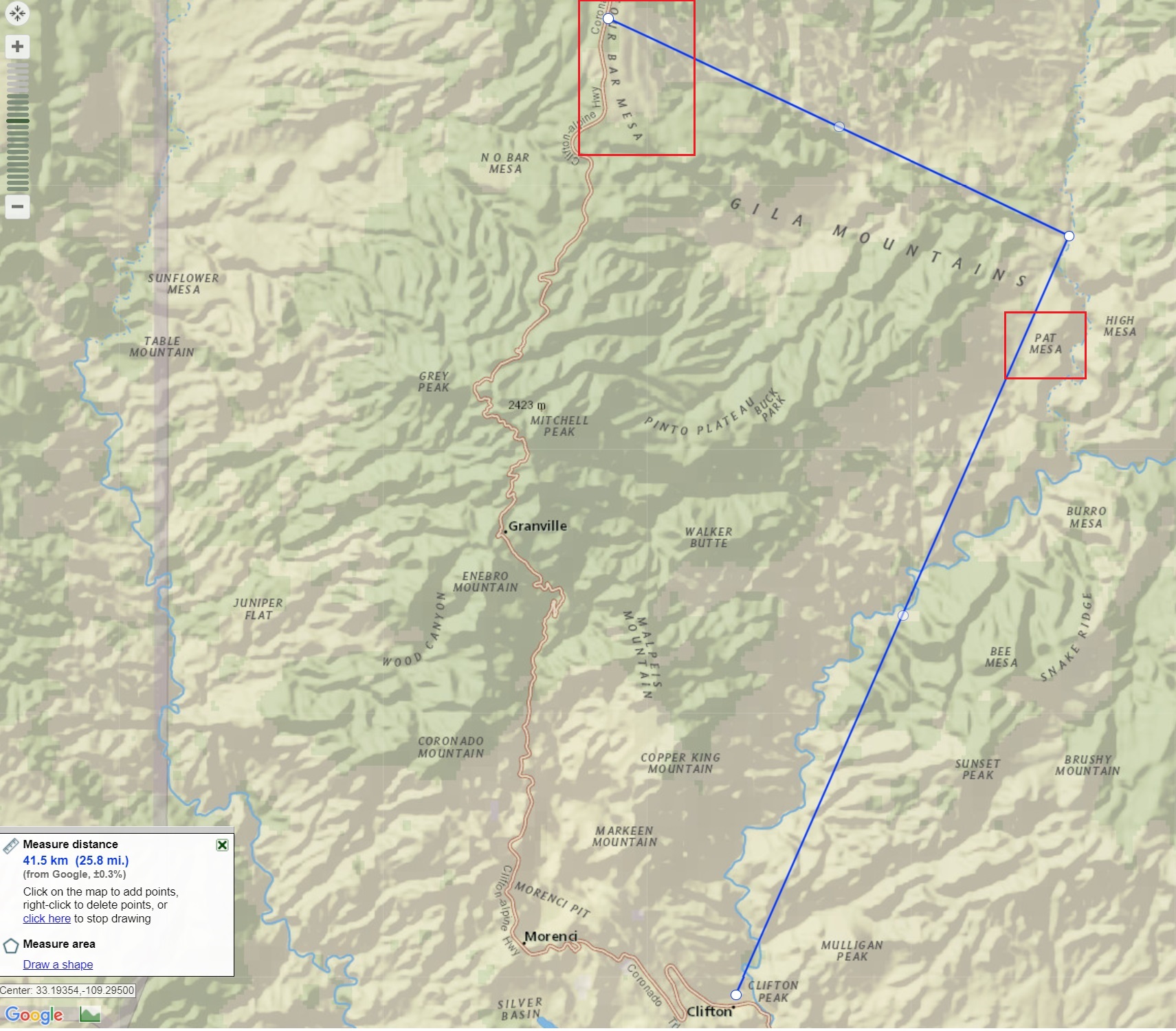
Potential re-route of Highway 191
Oddly enough due to the continued expansion of the Morenci Mine Highway 191 may eventually shift back to the Blue River. With preliminary plans for the highway to go up the San Francisco River where it will climb to Pat Mesa and rejoin the current highway at Four Bar Mesa eliminating many of the twists and turns the legendary highway is notorious for.
” Improvements and rerouting will continue and at some future time the winding old Coronado Trail may surrender to the villain named progress.” USDA FOREST SERVICE SOUTHWESTERN REGION ALBUQUERQUE, N.M.

Recent Comments